


FlightIntel
FlightIntel의 설명
미국 공항만 해당.
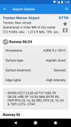
FlightIntel은 비행의 모든 단계에서 조종사에게 자원이 되도록 설계되었습니다. 5500개 이상의 미국 공공 공항에 대한 자세한 정보를 제공합니다. AF/D 데이터는 휴대전화에 다운로드되어 오프라인에서 사용할 수 있습니다.
귀하의 지원과 감사를 표시하기 위해 평가와 의견을 남겨주세요. 감사합니다.
특징:
=========
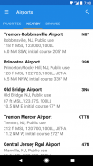
* 5,500개 이상의 미국 공용 공항에 대한 전체 정보
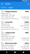
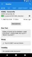
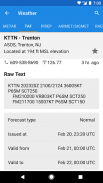
* 모든 비행 계획에 대한 자세한 Wx
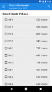
* 공항 다이어그램, d-CS 등 d-TPP 무료 이용
* FAA 데이터 주기에 따른 무료 데이터 업데이트
* TFR, Notams 및 D-ATIS
* E6B
* 스크래치패드
* 광범위한 항공 관련 서적 및 정기 간행물 PDF 라이브러리
* 미국 공항만 해당
* 광고 없음 및 개인 데이터 수집 없음
권한
===========
* 정밀(GPS) 위치 - 인근 공항/wx 스테이션을 표시하기 위해 현재 위치를 결정합니다.
* 전체 인터넷 액세스 - 데이터 파일, 날씨, NOTAMS, AeroNav PDF 등을 다운로드합니다.
* SD 카드 내용 수정/삭제 - 데이터 파일 저장, 날씨 데이터 및 PDF 캐시.
* 네트워크 상태 보기 - 인터넷에 연결되어 있는지 확인하고 다운로드를 위해 WIFI에 연결되어 있는지 확인합니다.
베타 테스트
==========
사용 가능한 경우 여기에서 베타 버전을 테스트하도록 선택할 수 있습니다.
https://play.google.com/apps/testing/com.nadmm.airports
Twitter 팔로우: @FlightIntel
사용자 그룹: https://groups.google.com/forum/?hl=ko&fromgroups#!forum/flightintel-users
이슈 트래커: https://github.com/nhasan/FlightIntel/issues
출처: https://github.com/nhasan/FlightIntel
*********************************************
중요: FC가 발생하는 경우 최신 릴리스를 실행하고 최신 데이터 업데이트를 설치했는지 확인하십시오.
*********************************************
FlightIntel - 버전 6.30.7
(20-10-2023)FlightIntel - APK 정보
APK 버전: 6.30.7패키지: com.nadmm.airportsFlightIntel의 최신 버전
다른 버전들


동일 카테고리의 앱


